
Posted 2/05/2026
A comprehensive approach to vegetation management planning on the Carson National Forest
By: Diana Leiker, Wildfire Mitigation Manager
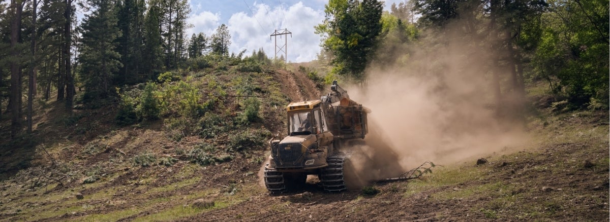
In the rugged terrain of northern New Mexico, keeping trees away from power lines is a critical part of protecting electric reliability and reducing wildfire risk. A focus of our recent vegetation management work was our transmission line on the Carson National Forest. The Black Lake-Taos transmission line required a large-scale vegetation management project to comprehensively improve electric reliability and to reduce wildfire risk. This complex project required extensive coordination between multiple departments at Tri-State and the Carson National Forest.
Located in what the US Forest Service describes as a Wildfire Crisis landscape, this stretch of transmission line runs through dense forest, steep terrain, and environmentally sensitive areas with high wildfire risk. It's also a region heavily used by hikers, campers, and other recreators. Additionally, there was significant private property and structures in the project area.
Tri-State seeks to remove vegetation within and adjacent to our transmission line rights-of-way to reduce impacts to the power line and to reduce the overall risk of wildfire to and from our infrastructure.

Modernizing large-scale vegetation management
Vegetation management planning requires extensive field surveys to identify the trees that need to be removed as well as the identification of access roads and decking locations where material will be processed and temporarily stored until it can be hauled away. The process also requires the delineation of areas where forestry equipment can safely operate versus areas where manual clearing and helicopter logging may be required due to terrain. The Black Lake-Taos transmission line crosses a rugged stretch of the Carson National Forest and required both traditional forestry equipment and helicopter logging. The time frame for scoping this project was limited and there was insufficient time to conduct a comprehensive timber inventory. This transmission line became a pilot study for the use of satellite data to help support the analysis of hazard trees within and adjacent to the power line right-of-way.
Tri-State utilized high-resolution, satellite derived data provided by a company that specializes in utility vegetation management. This data was used to support the scoping of the project and permitting with the Carson National Forest. The other benefit of using satellite data is that it provides a visual representation of hazardous vegetation, which is helpful for landowners as well as the state and federal partners we work with on these critical projects.

Streamlining permitting on the national forest
The new technology also had positive implications for project permitting. Vegetation maintenance on U.S. Forest Service land requires extensive agency coordination, and approvals often involve multiple rounds of documentation and review.
Izzy Beshouri, Transmission Siting, Permitting & Environmental planner at Tri-State, played a central role in navigating this process. “Early, transparent permitting and close partnership with the Forest Service and local stakeholders is how you deliver safe, durable results on federal lands,” remarked Beshouri.
Richard Hejde, Tri-State's Senior Construction field representative, led the effort to analyze and translate the satellite vegetation data into a product that was used to create the scope of work and support permitting efforts. Tri-State’s GIS and Asset Management departments are also critical partners in our data processing and collection efforts. Equipped with satellite vegetation data, the team was able to present clear, data-backed justifications for hazard tree removal. The satellite data allowed us to demonstrate the urgent need for this large-scale vegetation management project. While permitting still required time and careful coordination, the data brought a level of clarity that streamlined project scoping and approvals, which allowed Tri-State to reduce wildfire risk while minimizing environmental disturbance.
For Beshouri, those efficiencies mattered not just because they streamlined the project, but because they protected a place that is important to millions of people, animals, and ecosystems. “When you step into this forest, you feel called to protect it. That’s why this work matters: to safeguard a place many people care deeply about,” continued Beshouri.
Executing safely in challenging terrain
Hejde and his crew also translated planning into action. Hejde was able to analyze and incorporate the satellite data to prepare the scope of work for the bidders. “Anytime you can take unknowns away from a bidder, you’ll see downward cost pressure. The satellite data was a key component in helping us to define the scope more clearly,” explained Hejde.
In many areas, traditional ground-based logging was impractical due to terrain and access limitations. Therefore, helicopter logging became a critical component of the project. This approach introduced its own challenges. The area draws significant recreational traffic and flying logs over trails and campsites posed serious safety concerns. Hejde and Beshouri worked together using data collected in the field and satellite data to plan when and where the aircraft would fly, communicate temporary closures to the public, and minimize disruption while maintaining safety for workers and recreators alike. Denise Gibbons in the Lands Department has been critical in outreach to private landowners on the need for this work.
These large-scale vegetation management projects are complex and require significant coordination, and planning in order to successfully and safely meet project objectives, while minimizing impacts to the environment and the public.
The importance of partnerships
This work would not have been possible without strong partnerships and coordination with the staff of the Carson National Forest. The team coordinated project notice with local community organizations, including trail associations, local police and fire departments, and neighborhood associations, who were instrumental in distributing information to local residents and people recreating in the area. Tri-State’s Land Rights department works closely with landowners to explain the purpose and need for vegetation management on private property and ensures their concerns are incorporated into the planning process.

Internal and external partners were also critical to obtaining funding to support the collection of satellite vegetation data. Curtis Hartenstine, Wildfire Mitigation Coordinator, and External Funding Manager Jeff King worked to secure grant funding that enabled Tri-State to adopt and deploy the technology.
Other key partners included the New Mexico Energy, Minerals and Natural Resources Department (EMNRD), New Mexico State Forestry, Colorado Energy Office, and state foresters in both New Mexico and Colorado.
“New Mexico is proud to support Tri-State in their pursuit of reducing wildfire risk in New Mexico,” said New Mexico State Forester Laura McCarthy. “We are grateful for this public-utility partnership to work collaboratively on the ever-increasing wildfire threat. Together, we can mitigate risk and better safeguard our New Mexico communities and natural resources.”
In Colorado, similar support is helping to expand the use of satellite data for vegetation management. “We are pleased to support Tri-State Generation and Transmission in their efforts to reduce wildfire risk using satellite data to monitor and maintain transmission infrastructure,” said Will Toor, executive director of the Colorado Energy Office. “Grid monitoring and maintenance is essential to prevent fires while ensuring reliable access to electricity for all Coloradans. This data will help Tri-State and their member cooperative utilities provide reliable service to hundreds of thousands of Coloradans.”
Commitment to protecting the communities we serve
Tri-State has been conducting pro-active, large-scale vegetation management for decades. We continue to seek technologies that streamline our planning and permitting processes. Satellite data is an important tool in working towards those objectives. Reducing wildfire risk remains a priority across the region and projects like Black Lake–Taos demonstrate how utilities can move towards proactive, data-driven stewardship that protects infrastructure, public lands, and the communities they serve.
--
About Tri-State
Tri-State is a power supply cooperative, operating on a not-for-profit basis, serving electric distribution cooperatives and public power district member-owners in four states. Together with our members, we deliver reliable, affordable and responsible power to more than a million electricity consumers across nearly 200,000 square miles of the West. Visit www.tristate.coop.
Blog Posts

6 Energy-Saving Tips to Get Your Home Ready for Summer

Co-op-Powered Broadband Keeps People Connected When it Counts
Tri-State’s wholesale rates are stable, and forecasted to remain so to 2050

What is the Benefit of Being a Member of an Electric Co-op?